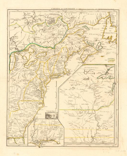
Title:
“Canada et Louisiane”
Map Maker:
George Louis Le Rouge
An important and scarce map issued at the outbreak... (full text available to subscribers)
| Item Detail |
| |
| |
MapMaker: |
George Louis Le Rouge
|
|
| |
| |
Subject: |
Colonial North America |
|
| |
Period/Size: |
1755 / 24.0" x 19.5" (61.0 x 49.6 cm)
|
|
| |
Color: |
Colored
|
|
| |
Condition: |
(B) Mostly fine with a few unobtrusive spots. (condition help) |
|
| |
Source: |
Atlas Ameriquain Septentrional |
|
| |
References: |
McCorkle #755.23; Sellers and van Ee #33. |
|
| |
|
|
| Sales Information |
| |
| |
Price: |
|
|
| |
| |
Offered by: |
Old World Auctions |
|
| |
Catalog: |
Auction No. 108 - Antique Maps, Charts, Atlases & Globes (362) |
|
| |
Lot/Item #: |
112 |
|
| |
| |
Date: |
09/2004
|
|
| |
| |
|
Antique Maps - Valuation and Pricing, Descriptions, Resources |
|
Home |
Information |
Search |
Register |
Contact Us |
Site Map
Americana Exchange, Inc. © 1999 - 2024 Americana Exchange, Inc.. All rights reserved.
OldMaps.com, the OldMaps.com logo and
AMPR are service marks or registered service marks of Americana Exchange, Inc..
|