Title:
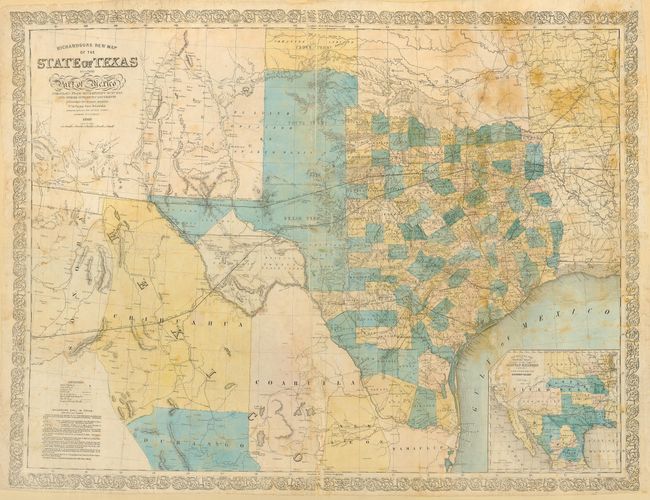
“Richardson's New Map of the State of Texas including part of Mexico. Compiled from government surveys and other authentic documents… corrected by H. Wickeland”
Map Maker:
Charles Desilver
This important antebellum map of Texas was issued ... (full text available to subscribers)
| Item Detail |
| |
| |
MapMaker: |
Charles Desilver
|
|
| |
| |
Subject: |
Texas |
|
| |
Period/Size: |
1860 / 24.6" x 32.0" (62.5 x 81.3 cm)
|
|
| |
Color: |
Colored
|
|
| |
Condition: |
(C) Laid down on mat board. Color slightly faded with some scattered foxing. Fragile paper with minor loss along folds. Please call for a more complete condition description. (condition help) |
|
| |
Source: |
The Texas Almanac |
|
| |
References: |
Day #1012; cf Phillips (M) p. 846 (1859 & 1861 editions); Rumsey #5178.000 (1861 ed.). |
|
| |
|
|
| Sales Information |
| |
| |
Price: |
|
|
| |
| |
Offered by: |
Old World Auctions |
|
| |
Catalog: |
Auction No. 108 - Antique Maps, Charts, Atlases & Globes (362) |
|
| |
Lot/Item #: |
229 |
|
| |
| |
Date: |
09/2004
|
|
| |
| |
|
Antique Maps - Valuation and Pricing, Descriptions, Resources |
|
Home |
Information |
Search |
Register |
Contact Us |
Site Map
Americana Exchange, Inc. © 1999 - 2024 Americana Exchange, Inc.. All rights reserved.
OldMaps.com, the OldMaps.com logo and
AMPR are service marks or registered service marks of Americana Exchange, Inc..
|