Title:
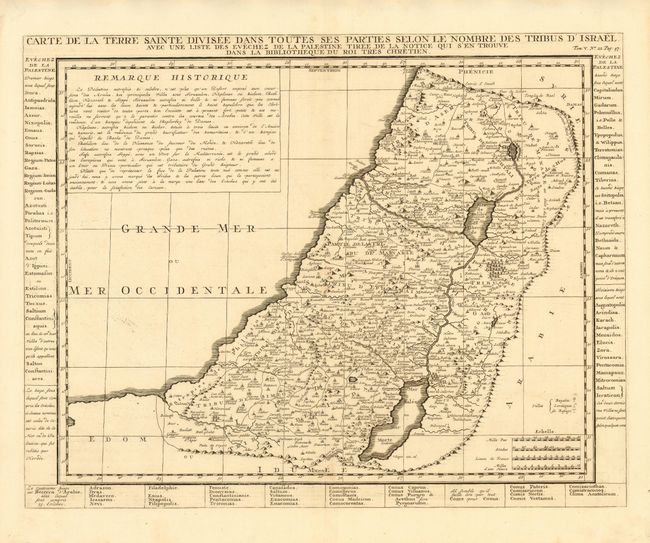
“Carte de la Terre Sainte Divisee dans Toutes ses Parties Selon le Nombre des Tribus d' Israel avec une liste des Evechez de la Palestine Tiree de la Notice qui s' en Trouve dans la Bibliotheque du Roi tres Chretien”
Map Maker:
Henry Abraham Chatelain
Detailed map of the Holy Land divided according to... (full text available to subscribers)
| Item Detail |
| |
| |
MapMaker: |
Henry Abraham Chatelain
|
|
| |
| |
Subject: |
Holy Land |
|
| |
Period/Size: |
1710 / 13.5" x 17.2" (34.3 x 43.7 cm)
|
|
| |
Color: |
Black & White
|
|
| |
Condition: |
(A) Sharp impression. Faint toning along fold, still very good. (condition help) |
|
| |
Source: |
Atlas Historique et Methodique |
|
| |
References: |
|
|
| |
|
|
| Sales Information |
| |
| |
Price: |
|
|
| |
| |
Offered by: |
Old World Auctions |
|
| |
Catalog: |
Auction No. 109 - Antique Maps, Charts, Atlases & Globes (385) |
|
| |
Lot/Item #: |
605 |
|
| |
| |
Date: |
12/2004
|
|
| |
| |
|
Antique Maps - Valuation and Pricing, Descriptions, Resources |
|
Home |
Information |
Search |
Register |
Contact Us |
Site Map
Americana Exchange, Inc. © 1999 - 2024 Americana Exchange, Inc.. All rights reserved.
OldMaps.com, the OldMaps.com logo and
AMPR are service marks or registered service marks of Americana Exchange, Inc..
|