Title:
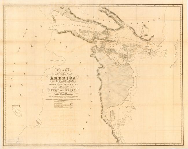
“Chart of a Part of the North Eastern Coast of America and its adjacent Islands, shewing the Track and Discoveries of His Majesty's Ships Fury and Hecla, in search of a North West Passage under the Command of Captn. W.E. Parry, in the years 1822-23”
Map Maker:
John Murray
Detailed sea chart showing the tracks of Parry's e... (full text available to subscribers)
| Item Detail |
| |
| |
MapMaker: |
John Murray
|
|
| |
| |
Subject: |
Canada |
|
| |
Period/Size: |
1824 / 22.0" x 28.2" (55.9 x 71.7 cm)
|
|
| |
Color: |
Black & White
|
|
| |
Condition: |
(B) Printed on strong banknote paper and issued folding. Light offsetting and some toning along folds. Couple of fold intersections reinforced with tissue. (condition help) |
|
| |
Source: |
|
|
| |
References: |
|
|
| |
|
|
| Sales Information |
| |
| |
Price: |
|
|
| |
| |
Offered by: |
Old World Auctions |
|
| |
Catalog: |
Auction No. 109 - Antique Maps, Charts, Atlases & Globes (385) |
|
| |
Lot/Item #: |
138 |
|
| |
| |
Date: |
12/2004
|
|
| |
| |
|
Antique Maps - Valuation and Pricing, Descriptions, Resources |
|
Home |
Information |
Search |
Register |
Contact Us |
Site Map
Americana Exchange, Inc. © 1999 - 2024 Americana Exchange, Inc.. All rights reserved.
OldMaps.com, the OldMaps.com logo and
AMPR are service marks or registered service marks of Americana Exchange, Inc..
|