Title:
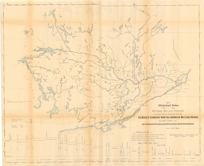
“Ottawa Canal Survey General Map and Profile of the Proposed Line of Navigation for Connecting the River St. Lawrence with the Geogian Bay, Lake Huron. By the Valleys of the Ottawa, the Mattawan, Lake Nippissingue, and the French River”
Map Maker:
Canadian Government
A large and remarkable map that shows an ambitious... (full text available to subscribers)
| Item Detail |
| |
| |
MapMaker: |
Canadian Government
|
|
| |
| |
Subject: |
Canada |
|
| |
Period/Size: |
1860 / 27.7" x 35.0" (70.4 x 88.9 cm)
|
|
| |
Color: |
Colored
|
|
| |
Condition: |
(B) Issued folding, now archival tissue backed. Light toning along some fold lines. (condition help) |
|
| |
Source: |
Office of Public Works Quebec |
|
| |
References: |
|
|
| |
|
|
| Sales Information |
| |
| |
Price: |
|
|
| |
| |
Offered by: |
Old World Auctions |
|
| |
Catalog: |
Auction No. 109 - Antique Maps, Charts, Atlases & Globes (385) |
|
| |
Lot/Item #: |
140 |
|
| |
| |
Date: |
12/2004
|
|
| |
| |
|
Antique Maps - Valuation and Pricing, Descriptions, Resources |
|
Home |
Information |
Search |
Register |
Contact Us |
Site Map
Americana Exchange, Inc. © 1999 - 2024 Americana Exchange, Inc.. All rights reserved.
OldMaps.com, the OldMaps.com logo and
AMPR are service marks or registered service marks of Americana Exchange, Inc..
|