Title:
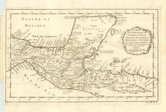
“Carte des Provinces de Tabasco, Chiapa, Verapaz, Guatimala, Honduras et Yucatan”
Map Maker:
Jacques Nicolas Bellin
Wonderfully detailed map of the Yucatan peninsula ... (full text available to subscribers)
| Item Detail |
| |
| |
MapMaker: |
Jacques Nicolas Bellin
|
|
| |
| |
Subject: |
Central America |
|
| |
Period/Size: |
1760 / 8.0" x 13.2" (20.4 x 33.6 cm)
|
|
| |
Color: |
Black & White
|
|
| |
Condition: |
(B) Overall very good with faint offsetting and a couple of unobtrusive spots. Issued folding, now pressed. (condition help) |
|
| |
Source: |
Prevost's L' Histoire Generale des Voyages |
|
| |
References: |
Kapp, Central America Early Maps, entry 45. |
|
| |
|
|
| Sales Information |
| |
| |
Price: |
|
|
| |
| |
Offered by: |
Old World Auctions |
|
| |
Catalog: |
Auction No. 109 - Antique Maps, Charts, Atlases & Globes (385) |
|
| |
Lot/Item #: |
285 |
|
| |
| |
Date: |
12/2004
|
|
| |
| |
|
Antique Maps - Valuation and Pricing, Descriptions, Resources |
|
Home |
Information |
Search |
Register |
Contact Us |
Site Map
Americana Exchange, Inc. © 1999 - 2024 Americana Exchange, Inc.. All rights reserved.
OldMaps.com, the OldMaps.com logo and
AMPR are service marks or registered service marks of Americana Exchange, Inc..
|