Title:
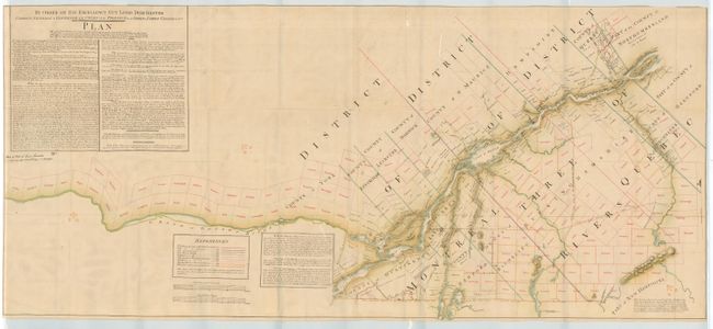
“By Order of His Excellency Guy Lord Dorchester Captain General & Governor in Chief of the Provinces of Upper & Lower Canada &c&c&c Plan…”
Map Maker:
Gale & Duberger
Later reprint of the famous manuscript map by Samu... (full text available to subscribers)
| Item Detail |
| |
| |
MapMaker: |
Gale & Duberger
|
|
| |
| |
Subject: |
Canada |
|
| |
Period/Size: |
1880-1900 / 26.0" x 57.5" (66.1 x 146.1 cm)
|
|
| |
Color: |
Colored
|
|
| |
Condition: |
(A) A few tears and fold splits, backed with linen. Still very good for a map of this size. (condition help) |
|
| |
Source: |
|
|
| |
References: |
|
|
| |
|
|
| Sales Information |
| |
| |
Price: |
|
|
| |
| |
Offered by: |
Old World Auctions |
|
| |
Catalog: |
Auction No. 109 - Antique Maps, Charts, Atlases & Globes (385) |
|
| |
Lot/Item #: |
141 |
|
| |
| |
Date: |
12/2004
|
|
| |
| |
|
Antique Maps - Valuation and Pricing, Descriptions, Resources |
|
Home |
Information |
Search |
Register |
Contact Us |
Site Map
Americana Exchange, Inc. © 1999 - 2024 Americana Exchange, Inc.. All rights reserved.
OldMaps.com, the OldMaps.com logo and
AMPR are service marks or registered service marks of Americana Exchange, Inc..
|