Title:
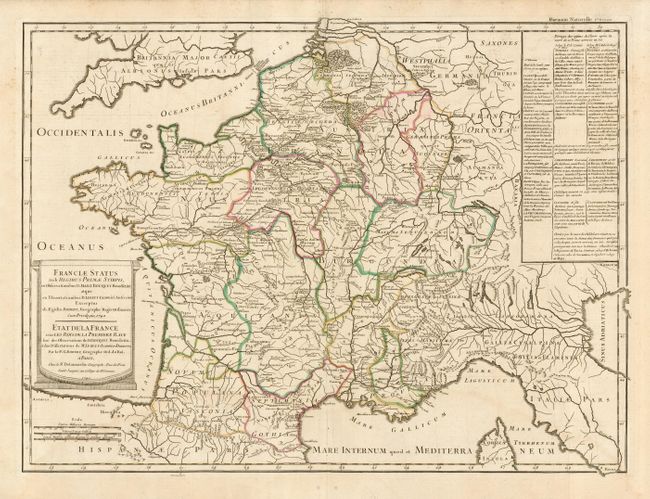
“Franciae Status sub Regibus Primae Stirpis…”
Map Maker:
Robert de Vaugondy/Delamarche
A historical map of France depicting the region at... (full text available to subscribers)
| Item Detail |
| |
| |
MapMaker: |
Robert de Vaugondy/Delamarche
|
|
| |
| |
Subject: |
France |
|
| |
Period/Size: |
1740 / 19.5" x 26.2" (49.6 x 66.6 cm)
|
|
| |
Color: |
Colored
|
|
| |
Condition: |
(B) Original outline color with slight bleed through on verso. Printer's crease 2" into map on top centerfold and very faint damp stain at bottom. (condition help) |
|
| |
Source: |
Bouquet's Receuil des Historiens de la France |
|
| |
References: |
Pedley #88. |
|
| |
|
|
| Sales Information |
| |
| |
Price: |
|
|
| |
| |
Offered by: |
Old World Auctions |
|
| |
Catalog: |
Auction No. 110 - Antique Maps, Charts, Atlases & Globes (386) |
|
| |
Lot/Item #: |
445 |
|
| |
| |
Date: |
03/2005
|
|
| |
| |
|
Antique Maps - Valuation and Pricing, Descriptions, Resources |
|
Home |
Information |
Search |
Register |
Contact Us |
Site Map
Americana Exchange, Inc. © 1999 - 2024 Americana Exchange, Inc.. All rights reserved.
OldMaps.com, the OldMaps.com logo and
AMPR are service marks or registered service marks of Americana Exchange, Inc..
|