Rister or Sign In to see pricing information


Title:

Nieuwe Kaart van Kanada, de Landen aan de Hudsons - Baay en de Noordwestelyke deelen van Noord-Amerika

Map Maker:

Isaac Tirion

Nieuwe Kaart van Kanada, de Landen aan de Hudsons - Baay en de Noordwestelyke deelen van Noord-Amerika

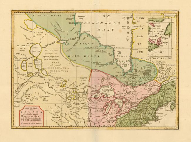
A very nice map based on Jefferys' important map o... (full text available to subscribers)
Item Detail
 
  MapMaker:  

Isaac Tirion


  Subject:  Colonial Great Lakes and Canada  
  Period/Size:  1769 / 12.0" x 17.0"  (30.5 x 43.2 cm)  
  Color:  Colored  
  Condition:  (A) Lovely original color and wide margins. Couple of faint spots, still very good. (condition help)  
  Source:  Nieuwe en Beknopte Hand Atlas  
  References:  Kershaw #375; McCorkle #769.2  
 
 
Sales Information
 
  Price: 

Please register your email to view records, or sign in with email address to see records


  Offered by:  Old World Auctions  
  Catalog:  Auction No. 110 - Antique Maps, Charts, Atlases & Globes (386)  
  Lot/Item #:  102  
 
  Date:  03/2005  


Antique Maps - Valuation and Pricing, Descriptions, Resources


Home | Information | Search | Register | Contact Us | Site Map

Americana Exchange, Inc. © 1999 - 2024 Americana Exchange, Inc.. All rights reserved. OldMaps.com, the OldMaps.com logo and
AMPR are service marks or registered service marks of Americana Exchange, Inc..