Title:
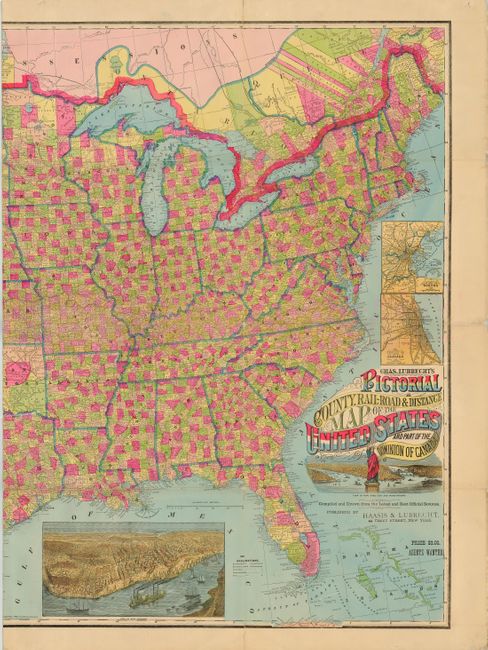
“Chas. Lubrecht's Pictorial County, Rail-Road & Distance Map of the United States and Part of the Dominion of Canada”
Map Maker:
Charles Lubrecht
This is an exceedingly scarce, folding rail... (full text available to subscribers)
| Item Detail |
| |
| |
MapMaker: |
Charles Lubrecht
|
|
| |
| |
Subject: |
United States |
|
| |
Period/Size: |
1880 / 36.5" x 56.4" (92.8 x 143.3 cm)
|
|
| |
Color: |
Colored
|
|
| |
Condition: |
(A) Professional reinforcement along folds with Japanese tissue. (condition help) |
|
| |
Source: |
|
|
| |
References: |
Phillips (M) p. 934; not listed in Modelski. |
|
| |
|
|
| Sales Information |
| |
| |
Price: |
|
|
| |
| |
Offered by: |
Old World Auctions |
|
| |
Catalog: |
Auction No. 110 - Antique Maps, Charts, Atlases & Globes (386) |
|
| |
Lot/Item #: |
116 |
|
| |
| |
Date: |
03/2005
|
|
| |
| |
|
Antique Maps - Valuation and Pricing, Descriptions, Resources |
|
Home |
Information |
Search |
Register |
Contact Us |
Site Map
Americana Exchange, Inc. © 1999 - 2024 Americana Exchange, Inc.. All rights reserved.
OldMaps.com, the OldMaps.com logo and
AMPR are service marks or registered service marks of Americana Exchange, Inc..
|