Title:
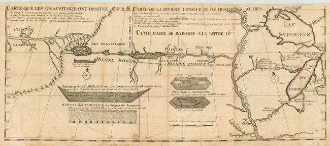
“Carte que les Gnacsitares ont Dessine sur Carte de la Riviere Longue et de Quelques Autres”
Map Maker:
Louis Armand de Lom d'Arce, de Lahontan
This is one of the most influential, and fanciful,... (full text available to subscribers)
| Item Detail |
| |
| |
MapMaker: |
Louis Armand de Lom d'Arce, de Lahontan
|
|
| |
| |
Subject: |
Colonial Midwest |
|
| |
Period/Size: |
1703 / 11.0" x 26.2" (28.0 x 66.6 cm)
|
|
| |
Color: |
Black & White
|
|
| |
Condition: |
(B) Lower left corner or map has been professionally replaced with facsimile of border and latitudinal scale and a couple of mountains. Light toning along fold with faint offsetting. (condition help) |
|
| |
Source: |
Nouveaux Voyages de M. le Baron de Lahontan dans l'Amerique Septentrionale |
|
| |
References: |
Kershaw #298; Verner & Stuart Stubbs #20;Lemmon, Magil & Wiese (LA) #14. |
|
| |
|
|
| Sales Information |
| |
| |
Price: |
|
|
| |
| |
Offered by: |
Old World Auctions |
|
| |
Catalog: |
Auction No. 110 - Antique Maps, Charts, Atlases & Globes (386) |
|
| |
Lot/Item #: |
146 |
|
| |
| |
Date: |
03/2005
|
|
| |
| |
|
Antique Maps - Valuation and Pricing, Descriptions, Resources |
|
Home |
Information |
Search |
Register |
Contact Us |
Site Map
Americana Exchange, Inc. © 1999 - 2024 Americana Exchange, Inc.. All rights reserved.
OldMaps.com, the OldMaps.com logo and
AMPR are service marks or registered service marks of Americana Exchange, Inc..
|