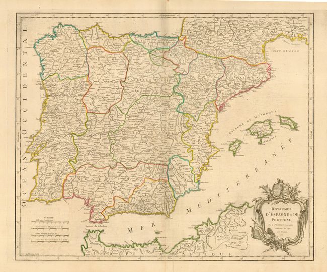
Title:
“Royaumes d' Espagne et de Portugal”
Map Maker:
Robert de Vaugondy [Family]
Large and detailed map that extends to show the La... (full text available to subscribers)
| Item Detail |
| |
| |
MapMaker: |
Robert de Vaugondy [Family]
|
|
| |
| |
Subject: |
Spain & Portugal |
|
| |
Period/Size: |
1750 / 19.0" x 23.0" (48.3 x 58.5 cm)
|
|
| |
Color: |
Colored
|
|
| |
Condition: |
(B) On a lovely full sheet of hand laid paper with wide margins. A little surface soiling and lightly toned along centerfold. Original outline coloring. (condition help) |
|
| |
Source: |
|
|
| |
References: |
|
|
| |
|
|
| Sales Information |
| |
| |
Price: |
|
|
| |
| |
Offered by: |
Old World Auctions |
|
| |
Catalog: |
Auction No. 110 - Antique Maps, Charts, Atlases & Globes (386) |
|
| |
Lot/Item #: |
547 |
|
| |
| |
Date: |
03/2005
|
|
| |
| |
|
Antique Maps - Valuation and Pricing, Descriptions, Resources |
|
Home |
Information |
Search |
Register |
Contact Us |
Site Map
Americana Exchange, Inc. © 1999 - 2024 Americana Exchange, Inc.. All rights reserved.
OldMaps.com, the OldMaps.com logo and
AMPR are service marks or registered service marks of Americana Exchange, Inc..
|