Title:
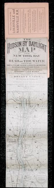
“The Hudson by Daylight Map from New York Bay to the Head of Tide Water Containing Names of Streams Islands and Height of Mountains According to the Latest Coast Survey Also the Names of Prominent Residences Historic Land Marks the Old Reaches….”
Map Maker:
Wallace Bruce
A remarkable map in strip-chart format that is ove... (full text available to subscribers)
| Item Detail |
| |
| |
MapMaker: |
Wallace Bruce
|
|
| |
| |
Subject: |
New York |
|
| |
Period/Size: |
1894 / 106.0" x 14.0" (269.3 x 35.6 cm)
|
|
| |
Color: |
Colored
|
|
| |
Condition: |
(A) A couple light coffee stains on cover. (condition help) |
|
| |
Source: |
Bryant Union Company |
|
| |
References: |
|
|
| |
|
|
| Sales Information |
| |
| |
Price: |
|
|
| |
| |
Offered by: |
Old World Auctions |
|
| |
Catalog: |
Auction No. 110 - Antique Maps, Charts, Atlases & Globes (386) |
|
| |
Lot/Item #: |
211 |
|
| |
| |
Date: |
03/2005
|
|
| |
| |
|
Antique Maps - Valuation and Pricing, Descriptions, Resources |
|
Home |
Information |
Search |
Register |
Contact Us |
Site Map
Americana Exchange, Inc. © 1999 - 2024 Americana Exchange, Inc.. All rights reserved.
OldMaps.com, the OldMaps.com logo and
AMPR are service marks or registered service marks of Americana Exchange, Inc..
|