Title:
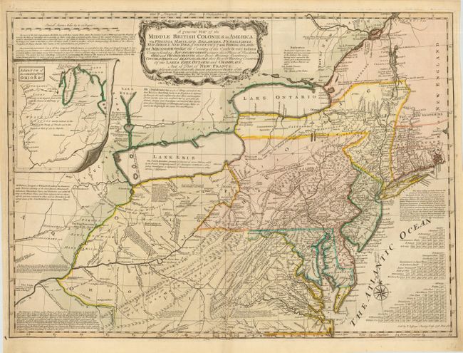
“A general Map of the Middle British Colonies in America: via Virginia, Maryland, Delaware, Pensilvania, New Jersey, New York, Connecticut and Rhode-Island…”
Map Maker:
Evans/Jefferys
This is the first state of Thomas Jefferys' deriva... (full text available to subscribers)
| Item Detail |
| |
| |
MapMaker: |
Evans/Jefferys
|
|
| |
| |
Subject: |
Colonial Mid Atlantic and Great Lakes |
|
| |
Period/Size: |
1758 / 19.0" x 26.2" (48.3 x 66.6 cm)
|
|
| |
Color: |
Colored
|
|
| |
Condition: |
(A+) Fine impression and original color. Very faint toning along fold, still fine. (condition help) |
|
| |
Source: |
|
|
| |
References: |
McCorkle 758.3; Steven & Tree #30-b. |
|
| |
|
|
| Sales Information |
| |
| |
Price: |
|
|
| |
| |
Offered by: |
Old World Auctions |
|
| |
Catalog: |
Auction No. 110 - Antique Maps, Charts, Atlases & Globes (386) |
|
| |
Lot/Item #: |
135 |
|
| |
| |
Date: |
03/2005
|
|
| |
| |
|
Antique Maps - Valuation and Pricing, Descriptions, Resources |
|
Home |
Information |
Search |
Register |
Contact Us |
Site Map
Americana Exchange, Inc. © 1999 - 2024 Americana Exchange, Inc.. All rights reserved.
OldMaps.com, the OldMaps.com logo and
AMPR are service marks or registered service marks of Americana Exchange, Inc..
|