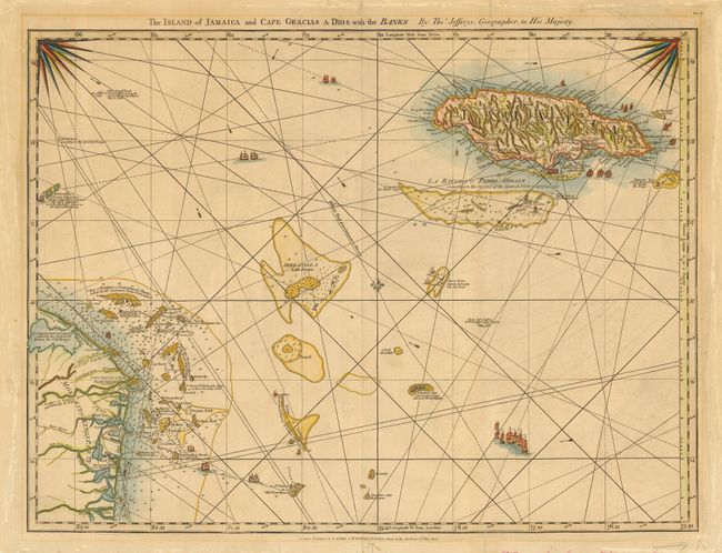
Title:
“The Island of Jamaica and Cape Gracias a Dios with the Banks”
Map Maker:
Thomas Jefferys
A superb chart of Jamaica and the Mosquito coasts ... (full text available to subscribers)
| Item Detail |
| |
| |
MapMaker: |
Thomas Jefferys
|
|
| |
| |
Subject: |
Caribbean |
|
| |
Period/Size: |
1794 / 18.5" x 25.0" (47.0 x 63.5 cm)
|
|
| |
Color: |
Colored
|
|
| |
Condition: |
(B) Light overall toning with minor mat burn and abrasions in blank margins. Professional repairs of short fold separations and marginal tears. Some ink notations in blank margins from a previous framing. (condition help) |
|
| |
Source: |
The West Indian Atlas |
|
| |
References: |
Sellers & Van Ee #1929. |
|
| |
|
|
| Sales Information |
| |
| |
Price: |
|
|
| |
| |
Offered by: |
Old World Auctions |
|
| |
Catalog: |
Auction No. 111 - Antique Maps, Charts, Atlases & Globes (387) |
|
| |
Lot/Item #: |
298 |
|
| |
| |
Date: |
06/2005
|
|
| |
| |
|
Antique Maps - Valuation and Pricing, Descriptions, Resources |
|
Home |
Information |
Search |
Register |
Contact Us |
Site Map
Americana Exchange, Inc. © 1999 - 2024 Americana Exchange, Inc.. All rights reserved.
OldMaps.com, the OldMaps.com logo and
AMPR are service marks or registered service marks of Americana Exchange, Inc..
|