Title:
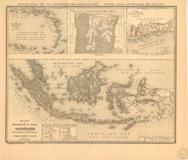
“Kaart der Nederlandsche Bezittingen in Oostindien. Possessions hollandaises aux Indes Orientales”
Map Maker:
Francois Desterecq
This obscure map provides remarkable detail throug... (full text available to subscribers)
| Item Detail |
| |
| |
MapMaker: |
Francois Desterecq
|
|
| |
| |
Subject: |
East Indies - Indonesia |
|
| |
Period/Size: |
1841 / 17.5" x 21.7" (44.5 x 55.2 cm)
|
|
| |
Color: |
Black & White
|
|
| |
Condition: |
(B) A few very light spots or stains. One area of abrasion just into lower border. Stamp of the Geographische Institute Utrecht is at lower right corner, well away from map. (condition help) |
|
| |
Source: |
Atlas der Nederlanden |
|
| |
References: |
|
|
| |
|
|
| Sales Information |
| |
| |
Price: |
|
|
| |
| |
Offered by: |
Old World Auctions |
|
| |
Catalog: |
Auction No. 111 - Antique Maps, Charts, Atlases & Globes (387) |
|
| |
Lot/Item #: |
663 |
|
| |
| |
Date: |
06/2005
|
|
| |
| |
|
Antique Maps - Valuation and Pricing, Descriptions, Resources |
|
Home |
Information |
Search |
Register |
Contact Us |
Site Map
Americana Exchange, Inc. © 1999 - 2024 Americana Exchange, Inc.. All rights reserved.
OldMaps.com, the OldMaps.com logo and
AMPR are service marks or registered service marks of Americana Exchange, Inc..
|