Title:
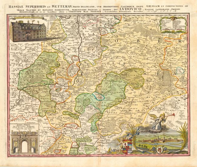
“Hassiae Superioris et Watterau. Partis delineatio, cum descriptione, Castrorum Prope Giessam et Coniunctionis ad..Ludovico…”
Map Maker:
Homann Heirs
A handsome copper engraved map centered on Giessen... (full text available to subscribers)
| Item Detail |
| |
| |
MapMaker: |
Homann Heirs
|
|
| |
| |
Subject: |
Germany |
|
| |
Period/Size: |
1746 / 18.0" x 22.0" (45.8 x 55.9 cm)
|
|
| |
Color: |
Colored
|
|
| |
Condition: |
(B) Fine original coloring and crisp impression with original margins. Toned along centerfold, else very good. (condition help) |
|
| |
Source: |
|
|
| |
References: |
|
|
| |
|
|
| Sales Information |
| |
| |
Price: |
|
|
| |
| |
Offered by: |
Old World Auctions |
|
| |
Catalog: |
Auction No. 111 - Antique Maps, Charts, Atlases & Globes (387) |
|
| |
Lot/Item #: |
480 |
|
| |
| |
Date: |
06/2005
|
|
| |
| |
|
Antique Maps - Valuation and Pricing, Descriptions, Resources |
|
Home |
Information |
Search |
Register |
Contact Us |
Site Map
Americana Exchange, Inc. © 1999 - 2024 Americana Exchange, Inc.. All rights reserved.
OldMaps.com, the OldMaps.com logo and
AMPR are service marks or registered service marks of Americana Exchange, Inc..
|