Title:
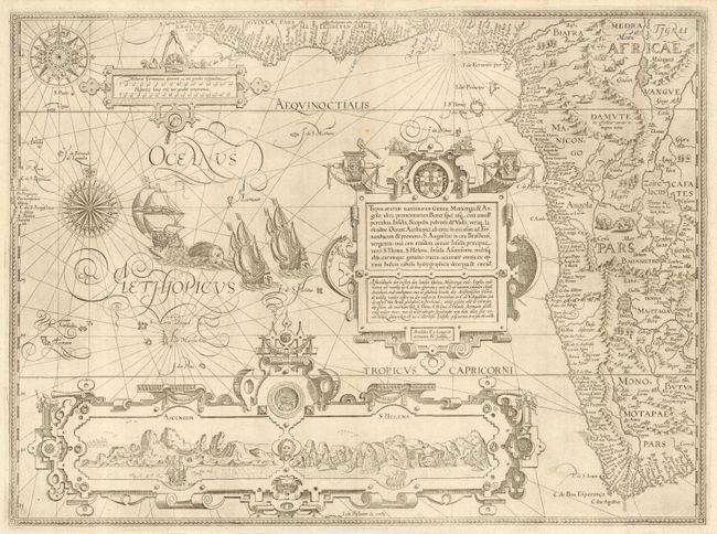
“Typus orarum maritimarum Guineae, Manicongo & Angolae ultra promontorium Bonae Spei usq…”
Map Maker:
Jan Huygen van Linschoten
This is one of the most richly ornamented maps in ... (full text available to subscribers)
| Item Detail |
| |
| |
MapMaker: |
Jan Huygen van Linschoten
|
|
| |
| |
Subject: |
Africa - Western |
|
| |
Period/Size: |
1596 / 15.5" x 21.0" (39.4 x 53.4 cm)
|
|
| |
Color: |
Black & White
|
|
| |
Condition: |
(A) Professional repairs of a couple of very tiny edge tears and along the outside fold. Good margins all around. (condition help) |
|
| |
Source: |
Itinerario… |
|
| |
References: |
Norwich 239a; Tooley MCCS No. 29, #167; Tooley et al [Landmarks] pp. 168-69. |
|
| |
|
|
| Sales Information |
| |
| |
Price: |
|
|
| |
| |
Offered by: |
Old World Auctions |
|
| |
Catalog: |
Auction No. 111 - Antique Maps, Charts, Atlases & Globes (387) |
|
| |
Lot/Item #: |
690 |
|
| |
| |
Date: |
06/2005
|
|
| |
| |
|
Antique Maps - Valuation and Pricing, Descriptions, Resources |
|
Home |
Information |
Search |
Register |
Contact Us |
Site Map
Americana Exchange, Inc. © 1999 - 2024 Americana Exchange, Inc.. All rights reserved.
OldMaps.com, the OldMaps.com logo and
AMPR are service marks or registered service marks of Americana Exchange, Inc..
|