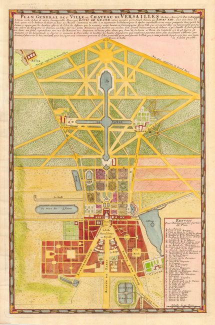
Title:
“Plan General des Ville et Chateau de Versailles”
Map Maker:
Pierre Mortier
Attractive and detailed plan of the chateau and ga... (full text available to subscribers)
| Item Detail |
| |
| |
MapMaker: |
Pierre Mortier
|
|
| |
| |
Subject: |
France |
|
| |
Period/Size: |
1695 / 18.9" x 12.2" (48.0 x 31.0 cm)
|
|
| |
Color: |
Colored
|
|
| |
Condition: |
(A) Expertly remargined to replace binding trim including skilled facsimile of neatline on bottom left corner. (condition help) |
|
| |
Source: |
|
|
| |
References: |
|
|
| |
|
|
| Sales Information |
| |
| |
Price: |
|
|
| |
| |
Offered by: |
Old World Auctions |
|
| |
Catalog: |
Auction No. 111 - Antique Maps, Charts, Atlases & Globes (387) |
|
| |
Lot/Item #: |
445 |
|
| |
| |
Date: |
06/2005
|
|
| |
| |
|
Antique Maps - Valuation and Pricing, Descriptions, Resources |
|
Home |
Information |
Search |
Register |
Contact Us |
Site Map
Americana Exchange, Inc. © 1999 - 2024 Americana Exchange, Inc.. All rights reserved.
OldMaps.com, the OldMaps.com logo and
AMPR are service marks or registered service marks of Americana Exchange, Inc..
|