Title:
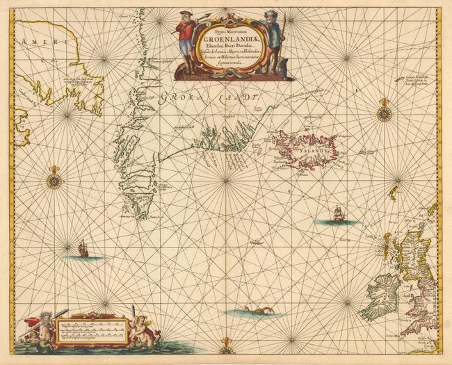
“Typus Maritimus Groenlandiae, Islandiae, Freti Davidis, Insulae Johannis Mayen, et Hitlandiae, Scotiae, et Hiberniae litora maritima Septentrionalia”
Map Maker:
Jan Jansson
This handsome chart is a close copy of the Jocobsz... (full text available to subscribers)
| Item Detail |
| |
| |
MapMaker: |
Jan Jansson
|
|
| |
| |
Subject: |
North Atlantic and Arctic |
|
| |
Period/Size: |
1659 / 16.8" x 20.9" (42.7 x 53.1 cm)
|
|
| |
Color: |
Colored
|
|
| |
Condition: |
(A+) (condition help) |
|
| |
Source: |
|
|
| |
References: |
van der Krogt (Atlantes) #0110:1. |
|
| |
|
|
| Sales Information |
| |
| |
Price: |
|
|
| |
| |
Offered by: |
Old World Auctions |
|
| |
Catalog: |
Auction No. 111 - Antique Maps, Charts, Atlases & Globes (387) |
|
| |
Lot/Item #: |
346 |
|
| |
| |
Date: |
06/2005
|
|
| |
| |
|
Antique Maps - Valuation and Pricing, Descriptions, Resources |
|
Home |
Information |
Search |
Register |
Contact Us |
Site Map
Americana Exchange, Inc. © 1999 - 2024 Americana Exchange, Inc.. All rights reserved.
OldMaps.com, the OldMaps.com logo and
AMPR are service marks or registered service marks of Americana Exchange, Inc..
|