Title:
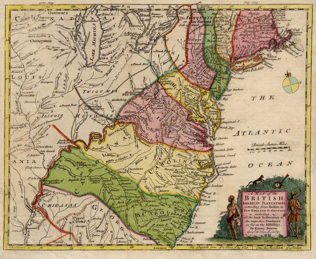
“A Map of the British American Plantations extending from Boston in New England to Georgia; including all the back Settlements in the respective Provinces, as far as the Mississipi”
Map Maker:
Emanuel Bowen
Splendid little map covering the area east of the ... (full text available to subscribers)
| Item Detail |
| |
| |
MapMaker: |
Emanuel Bowen
|
|
| |
| |
Subject: |
Colonial Mid-Atlantic |
|
| |
Period/Size: |
1754 / 8.6" x 10.7" (21.9 x 27.2 cm)
|
|
| |
Color: |
Colored
|
|
| |
Condition: |
(A) Margin extended at binding trim. Fine old color (condition help) |
|
| |
Source: |
Gentlemans Magazine |
|
| |
References: |
Cumming (SE) #272; Jolly GENT-89; McCorkle #754-1; Sellers & Van Ee #708. |
|
| |
|
|
| Sales Information |
| |
| |
Price: |
|
|
| |
| |
Offered by: |
Old World Auctions |
|
| |
Catalog: |
Auction No. 111 - Antique Maps, Charts, Atlases & Globes (387) |
|
| |
Lot/Item #: |
136 |
|
| |
| |
Date: |
06/2005
|
|
| |
| |
|
Antique Maps - Valuation and Pricing, Descriptions, Resources |
|
Home |
Information |
Search |
Register |
Contact Us |
Site Map
Americana Exchange, Inc. © 1999 - 2024 Americana Exchange, Inc.. All rights reserved.
OldMaps.com, the OldMaps.com logo and
AMPR are service marks or registered service marks of Americana Exchange, Inc..
|