Title:
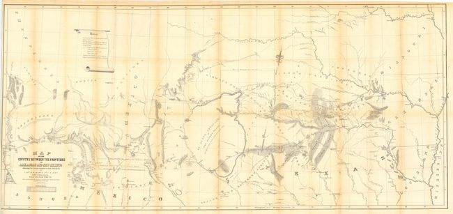
“Map of the Country between the frontiers of Arkansas and New Mexico embracing the section explored in 1849, 50, 51 & 52, by Capt. R.B. Marcy…”
Map Maker:
U.S. War Department
Title continues "5th U.S. Infy. under orders from ... (full text available to subscribers)
| Item Detail |
| |
| |
MapMaker: |
U.S. War Department
|
|
| |
| |
Subject: |
Southwestern United States |
|
| |
Period/Size: |
1852 / 27.5" x 59.5" (69.9 x 151.2 cm)
|
|
| |
Color: |
Black & White
|
|
| |
Condition: |
(B) Good impression on sound paper. Issued folding, now pressed and backed with archival tissue. Close trimmed to neatline at lower left side, as issued. Toned along some folds, else very good. (condition help) |
|
| |
Source: |
Exploration of the Red River in Louisiana in the year 1852 |
|
| |
References: |
Wheat (TMW) 791 |
|
| |
|
|
| Sales Information |
| |
| |
Price: |
|
|
| |
| |
Offered by: |
Old World Auctions |
|
| |
Catalog: |
Auction No. 112 - Antique Maps, Charts, Atlases & Globes (565) |
|
| |
Lot/Item #: |
203 |
|
| |
| |
Date: |
09/2005
|
|
| |
| |
|
Antique Maps - Valuation and Pricing, Descriptions, Resources |
|
Home |
Information |
Search |
Register |
Contact Us |
Site Map
Americana Exchange, Inc. © 1999 - 2024 Americana Exchange, Inc.. All rights reserved.
OldMaps.com, the OldMaps.com logo and
AMPR are service marks or registered service marks of Americana Exchange, Inc..
|