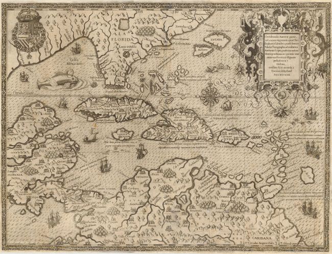
Title:
“Occidentalis Americae partis, vel earum Regionum quas Christophorus Columbus…”
Map Maker:
Theodore de Bry
This spectacular map illustrates the region travel... (full text available to subscribers)
| Item Detail |
| |
| |
MapMaker: |
Theodore de Bry
|
|
| |
| |
Subject: |
Caribbean |
|
| |
Period/Size: |
1594 / 13.0" x 17.5" (33.1 x 44.5 cm)
|
|
| |
Color: |
Black & White
|
|
| |
Condition: |
(B) Professionally and expertly repaired including some paper restoration and very skillful facsimile along the centerfold. The work is extremely well done and does not detract from the overall attractiveness of this rare map. (condition help) |
|
| |
Source: |
Grands Voyages, part IV |
|
| |
References: |
Burden #83; Potter p.164. |
|
| |
|
|
| Sales Information |
| |
| |
Price: |
|
|
| |
| |
Offered by: |
Old World Auctions |
|
| |
Catalog: |
Auction No. 112 - Antique Maps, Charts, Atlases & Globes (565) |
|
| |
Lot/Item #: |
321 |
|
| |
| |
Date: |
09/2005
|
|
| |
| |
|
Antique Maps - Valuation and Pricing, Descriptions, Resources |
|
Home |
Information |
Search |
Register |
Contact Us |
Site Map
Americana Exchange, Inc. © 1999 - 2024 Americana Exchange, Inc.. All rights reserved.
OldMaps.com, the OldMaps.com logo and
AMPR are service marks or registered service marks of Americana Exchange, Inc..
|