Title:
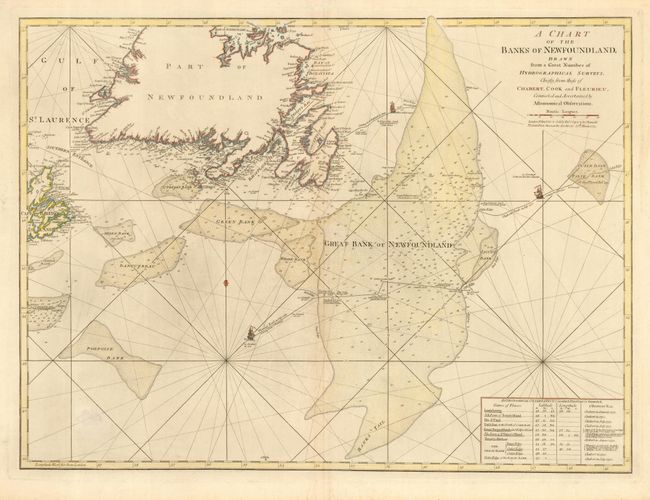
“A Chart of the Banks of Newfoundland Drawn from a Number of Hydrographical Surveys…of Chabert, Cook and Fleurieu…”
Map Maker:
Jefferys/Sayer & Bennett
Fine large-scale chart of Newfoundland, part of Ca... (full text available to subscribers)
| Item Detail |
| |
| |
MapMaker: |
Jefferys/Sayer & Bennett
|
|
| |
| |
Subject: |
Canada |
|
| |
Period/Size: |
1775 / 19.5" x 26.5" (49.6 x 67.4 cm)
|
|
| |
Color: |
Colored
|
|
| |
Condition: |
(B) Bit of unobtrusive soil. (condition help) |
|
| |
Source: |
The American Atlas |
|
| |
References: |
Phillips (A) 1165-13. |
|
| |
|
|
| Sales Information |
| |
| |
Price: |
|
|
| |
| |
Offered by: |
Old World Auctions |
|
| |
Catalog: |
Auction No. 112 - Antique Maps, Charts, Atlases & Globes (565) |
|
| |
Lot/Item #: |
108 |
|
| |
| |
Date: |
09/2005
|
|
| |
| |
|
Antique Maps - Valuation and Pricing, Descriptions, Resources |
|
Home |
Information |
Search |
Register |
Contact Us |
Site Map
Americana Exchange, Inc. © 1999 - 2024 Americana Exchange, Inc.. All rights reserved.
OldMaps.com, the OldMaps.com logo and
AMPR are service marks or registered service marks of Americana Exchange, Inc..
|