Title:
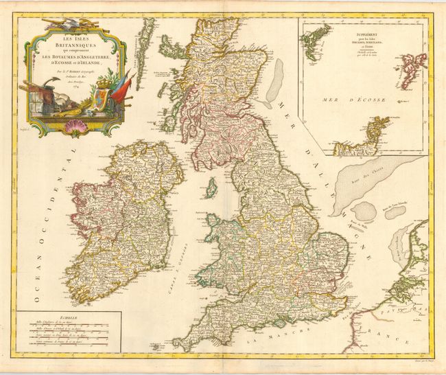
“Les Isles Britanniques qui comprennent les Royaumes d' Angleterre, d' Ecosse et d' Irlande”
Map Maker:
Gilles Robert de Vaugondy
First state of this fine map of the British Isles ... (full text available to subscribers)
| Item Detail |
| |
| |
MapMaker: |
Gilles Robert de Vaugondy
|
|
| |
| |
Subject: |
Britain |
|
| |
Period/Size: |
1754 / 18.7" x 23.5" (47.5 x 59.7 cm)
|
|
| |
Color: |
Colored
|
|
| |
Condition: |
(A) Good impression and color. Slight extra crease at centerfold. Tissue repair of short fold separations (condition help) |
|
| |
Source: |
Atlas Universel |
|
| |
References: |
Pedley #43. |
|
| |
|
|
| Sales Information |
| |
| |
Price: |
|
|
| |
| |
Offered by: |
Old World Auctions |
|
| |
Catalog: |
Auction No. 112 - Antique Maps, Charts, Atlases & Globes (565) |
|
| |
Lot/Item #: |
379 |
|
| |
| |
Date: |
09/2005
|
|
| |
| |
|
Antique Maps - Valuation and Pricing, Descriptions, Resources |
|
Home |
Information |
Search |
Register |
Contact Us |
Site Map
Americana Exchange, Inc. © 1999 - 2024 Americana Exchange, Inc.. All rights reserved.
OldMaps.com, the OldMaps.com logo and
AMPR are service marks or registered service marks of Americana Exchange, Inc..
|