Title:
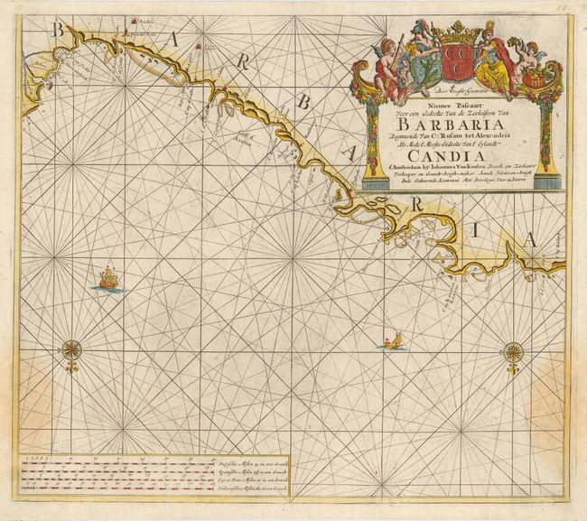
“Nieuwe Pascaart Voor een Gedeelte van de Zeekusten van Barbaria beginnende van C: Rusato tot Alexandria als mede t' meeste gedeelte van't Eylandt Candia”
Map Maker:
Johannes van Keulen
Interesting sea chart of the coast of Africa from ... (full text available to subscribers)
| Item Detail |
| |
| |
MapMaker: |
Johannes van Keulen
|
|
| |
| |
Subject: |
Northern Africa |
|
| |
Period/Size: |
1680 / 20.0" x 23.0" (50.8 x 58.5 cm)
|
|
| |
Color: |
Colored
|
|
| |
Condition: |
(B) Beautiful impression and coloring on fine hand laid paper. Margins appear to be original and vary 1/2" to 3/4". Large but faint stain at lower right and left. (condition help) |
|
| |
Source: |
De Nieuwe Groote Lichtende Zee-Fackel… |
|
| |
References: |
Phillips (A) #3444-17. |
|
| |
|
|
| Sales Information |
| |
| |
Price: |
|
|
| |
| |
Offered by: |
Old World Auctions |
|
| |
Catalog: |
Auction No. 113 - Antique Maps, Charts, Atlases & Globes (566) |
|
| |
Lot/Item #: |
774 |
|
| |
| |
Date: |
12/2005
|
|
| |
| |
|
Antique Maps - Valuation and Pricing, Descriptions, Resources |
|
Home |
Information |
Search |
Register |
Contact Us |
Site Map
Americana Exchange, Inc. © 1999 - 2024 Americana Exchange, Inc.. All rights reserved.
OldMaps.com, the OldMaps.com logo and
AMPR are service marks or registered service marks of Americana Exchange, Inc..
|