Title:
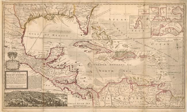
“A Map of the West Indies or the Islands of America in the North Sea; with ye adjacent Countries; explaining what belongs to Spain, England, France, Holland &c. Also ye Trade Winds, and ye several Tracts made by ye Galeons and Flota from Place to Place”
Map Maker:
Herman Moll
This large and incredible chart is filled with so ... (full text available to subscribers)
| Item Detail |
| |
| |
MapMaker: |
Herman Moll
|
|
| |
| |
Subject: |
Colonial America |
|
| |
Period/Size: |
1720 / 23.3" x 40.0" (59.2 x 101.6 cm)
|
|
| |
Color: |
Colored
|
|
| |
Condition: |
(B) A very nice example with strong impression and original color. Light stain along Gulf Coast. Professionally backed with thick archival paper. Tiny amount of loss just affecting border at two folds. (condition help) |
|
| |
Source: |
The World Described, or a New and Correct Sett of Maps |
|
| |
References: |
|
|
| |
|
|
| Sales Information |
| |
| |
Price: |
|
|
| |
| |
Offered by: |
Old World Auctions |
|
| |
Catalog: |
Auction No. 113 - Antique Maps, Charts, Atlases & Globes (566) |
|
| |
Lot/Item #: |
096 |
|
| |
| |
Date: |
12/2005
|
|
| |
| |
|
Antique Maps - Valuation and Pricing, Descriptions, Resources |
|
Home |
Information |
Search |
Register |
Contact Us |
Site Map
Americana Exchange, Inc. © 1999 - 2024 Americana Exchange, Inc.. All rights reserved.
OldMaps.com, the OldMaps.com logo and
AMPR are service marks or registered service marks of Americana Exchange, Inc..
|