Title:
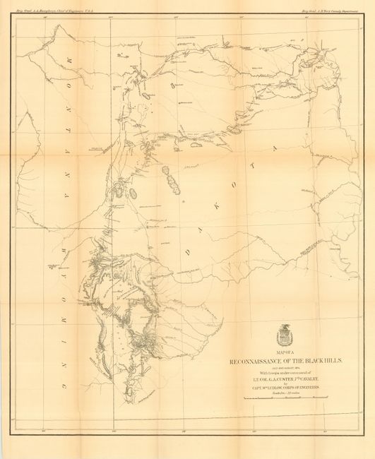
“Map of a Reconnaissance of the Black Hills, July and August 1874, with Troops under the Command of Lt. Col. G. A. Custer, 7th Calvary”
Map Maker:
William Ludlow
This is Ludlow's principle map that shows the enti... (full text available to subscribers)
| Item Detail |
| |
| |
MapMaker: |
William Ludlow
|
|
| |
| |
Subject: |
South Dakota |
|
| |
Period/Size: |
1874 / 25.5" x 21.0" (64.8 x 53.4 cm)
|
|
| |
Color: |
Black & White
|
|
| |
Condition: |
(B) Folding, as issued. A little light toning along two folds, some tiny fold intersection splits, else very good. (condition help) |
|
| |
Source: |
Report of a Reconnaissance of the Black Hills of Dakota |
|
| |
References: |
Wheat (TMW) #1248. |
|
| |
|
|
| Sales Information |
| |
| |
Price: |
|
|
| |
| |
Offered by: |
Old World Auctions |
|
| |
Catalog: |
Auction No. 114 - Antique Maps, Charts, Atlases & Globes (567) |
|
| |
Lot/Item #: |
274 |
|
| |
| |
Date: |
03/2006
|
|
| |
| |
|
Antique Maps - Valuation and Pricing, Descriptions, Resources |
|
Home |
Information |
Search |
Register |
Contact Us |
Site Map
Americana Exchange, Inc. © 1999 - 2024 Americana Exchange, Inc.. All rights reserved.
OldMaps.com, the OldMaps.com logo and
AMPR are service marks or registered service marks of Americana Exchange, Inc..
|