Rister or Sign In to see pricing information


Title:

Reconnaissance of Catalina Harbor and the Anchorage on the N. E. Side of the Island

Map Maker:

U.S. Coast Survey

Reconnaissance of Catalina Harbor and the Anchorage on the N. E. Side of the Island

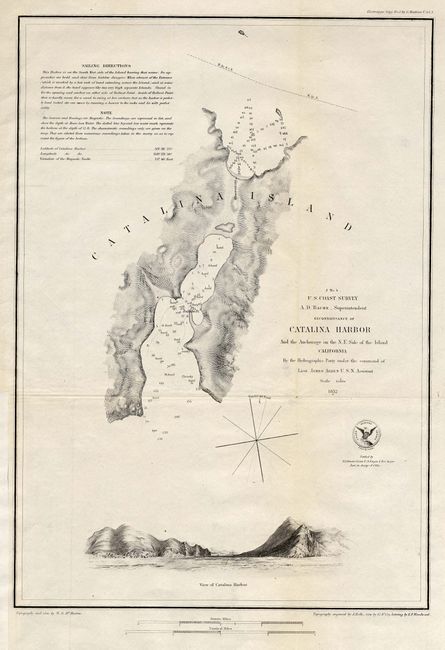
Seldom seen chart detailing Catalina Harbor and pa... (full text available to subscribers)
Item Detail
 
  MapMaker:  

U.S. Coast Survey


  Subject:  California  
  Period/Size:  1852 / 14.8" x 10.5"  (37.6 x 26.7 cm)  
  Color:  Black & White  
  Condition:  (A) Issued folding, now pressed. Extra paper added to binding trim, well away from neatline. Hint of toning and one tiny fold intersection split, still very good. (condition help)  
  Source:   
  References:   
 
 
Sales Information
 
  Price: 

Please register your email to view records, or sign in with email address to see records


  Offered by:  Old World Auctions  
  Catalog:  Auction No. 114 - Antique Maps, Charts, Atlases & Globes (567)  
  Lot/Item #:  211  
 
  Date:  03/2006  


Antique Maps - Valuation and Pricing, Descriptions, Resources


Home | Information | Search | Register | Contact Us | Site Map

Americana Exchange, Inc. © 1999 - 2024 Americana Exchange, Inc.. All rights reserved. OldMaps.com, the OldMaps.com logo and
AMPR are service marks or registered service marks of Americana Exchange, Inc..