Title:
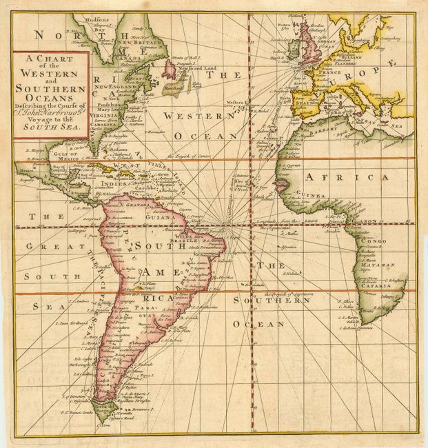
“A Chart of the Western and Southern Oceans Describing the Course of Sr. John Narbrough's Voyage to the South Sea,”
Map Maker:
Tancred Robinson
Attractive chart centered on the Atlantic Ocean an... (full text available to subscribers)
| Item Detail |
| |
| |
MapMaker: |
Tancred Robinson
|
|
| |
| |
Subject: |
Atlantic Ocean |
|
| |
Period/Size: |
1711 / 10.4" x 10.0" (26.5 x 25.4 cm)
|
|
| |
Color: |
Colored
|
|
| |
Condition: |
(A) Normal binding trim in right margin. (condition help) |
|
| |
Source: |
An Account of Several Late Voyages and Discoveries |
|
| |
References: |
|
|
| |
|
|
| Sales Information |
| |
| |
Price: |
|
|
| |
| |
Offered by: |
Old World Auctions |
|
| |
Catalog: |
Auction No. 114 - Antique Maps, Charts, Atlases & Globes (567) |
|
| |
Lot/Item #: |
345 |
|
| |
| |
Date: |
03/2006
|
|
| |
| |
|
Antique Maps - Valuation and Pricing, Descriptions, Resources |
|
Home |
Information |
Search |
Register |
Contact Us |
Site Map
Americana Exchange, Inc. © 1999 - 2024 Americana Exchange, Inc.. All rights reserved.
OldMaps.com, the OldMaps.com logo and
AMPR are service marks or registered service marks of Americana Exchange, Inc..
|