Title:
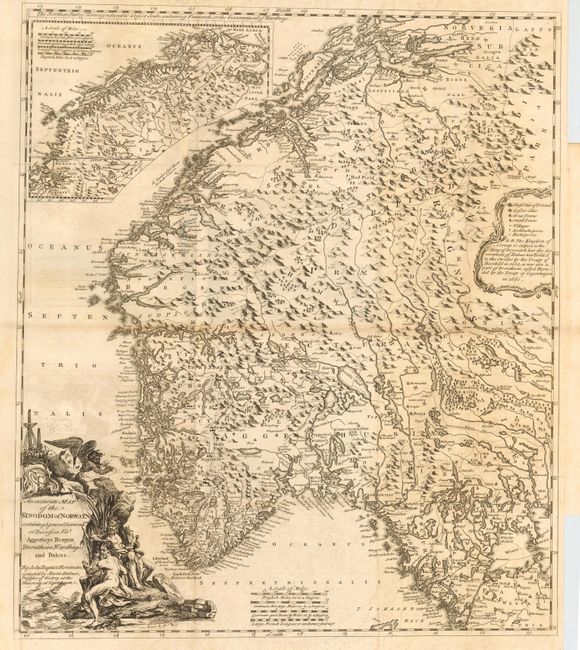
“An Accurate Map of the Kingdom of Norway, containing 5 general Governments of Diocesses…Aggerhuys Bergen Drontheim, Wardhuys, and Bahus”
Map Maker:
Johann Baptist Homann
Very detailed and strongly engraved chart after Ho... (full text available to subscribers)
| Item Detail |
| |
| |
MapMaker: |
Johann Baptist Homann
|
|
| |
| |
Subject: |
Norway |
|
| |
Period/Size: |
1755 / 22.2" x 19.2" (56.4 x 48.8 cm)
|
|
| |
Color: |
Black & White
|
|
| |
Condition: |
(B) Good impression on thick hand laid paper. Issued folding, now pressed. Light offsetting visible in blank areas and some toning along folds. (condition help) |
|
| |
Source: |
Natural History of Norway |
|
| |
References: |
|
|
| |
|
|
| Sales Information |
| |
| |
Price: |
|
|
| |
| |
Offered by: |
Old World Auctions |
|
| |
Catalog: |
Auction No. 114 - Antique Maps, Charts, Atlases & Globes (567) |
|
| |
Lot/Item #: |
379 |
|
| |
| |
Date: |
03/2006
|
|
| |
| |
|
Antique Maps - Valuation and Pricing, Descriptions, Resources |
|
Home |
Information |
Search |
Register |
Contact Us |
Site Map
Americana Exchange, Inc. © 1999 - 2024 Americana Exchange, Inc.. All rights reserved.
OldMaps.com, the OldMaps.com logo and
AMPR are service marks or registered service marks of Americana Exchange, Inc..
|