Title:
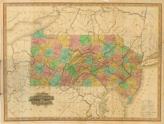
“A Map of the Canals & Railroads of Pennsylvania and New Jersey and the Adjoining States by H. S. Tanner”
Map Maker:
Henry Schenck Tanner
This scarce pocket map folds into green gilt-stamp... (full text available to subscribers)
| Item Detail |
| |
| |
MapMaker: |
Henry Schenck Tanner
|
|
| |
| |
Subject: |
Pennsylvania & New Jersey |
|
| |
Period/Size: |
1841 / 20.0" x 27.3" (50.8 x 69.4 cm)
|
|
| |
Color: |
Colored
|
|
| |
Condition: |
(B) Covers lightly rubbed. The map is bright but with several folds reinforced on verso to support a brittle fold. A little offsetting visible in blank regions surrounding map and a couple spots. (condition help) |
|
| |
Source: |
|
|
| |
References: |
cf Phillips (Maps) p. 681. |
|
| |
|
|
| Sales Information |
| |
| |
Price: |
|
|
| |
| |
Offered by: |
Old World Auctions |
|
| |
Catalog: |
Auction No. 114 - Antique Maps, Charts, Atlases & Globes (567) |
|
| |
Lot/Item #: |
269 |
|
| |
| |
Date: |
03/2006
|
|
| |
| |
|
Antique Maps - Valuation and Pricing, Descriptions, Resources |
|
Home |
Information |
Search |
Register |
Contact Us |
Site Map
Americana Exchange, Inc. © 1999 - 2024 Americana Exchange, Inc.. All rights reserved.
OldMaps.com, the OldMaps.com logo and
AMPR are service marks or registered service marks of Americana Exchange, Inc..
|