Title:
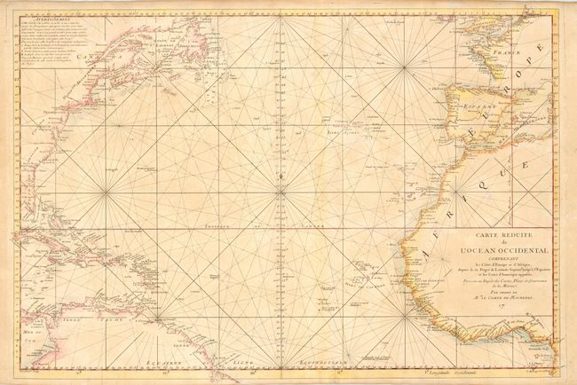
“Carte Reduite de l'Ocean Occidental Comprenent les Cotes d'Europe et d'Afrique…et les Cotes d'Amerique opposees…”
Map Maker:
Depot de la Marine
Large attractive sea chart of the North Atlantic w... (full text available to subscribers)
| Item Detail |
| |
| |
MapMaker: |
Depot de la Marine
|
|
| |
| |
Subject: |
Atlantic Ocean |
|
| |
Period/Size: |
1743 / 20.5" x 30.5" (52.1 x 77.5 cm)
|
|
| |
Color: |
Colored
|
|
| |
Condition: |
(B) Some uneven toning and color slightly faded. Folds unnecessarily reinforced with tissue on verso. Few minor repaired tears in margins. (condition help) |
|
| |
Source: |
|
|
| |
References: |
|
|
| |
|
|
| Sales Information |
| |
| |
Price: |
|
|
| |
| |
Offered by: |
Old World Auctions |
|
| |
Catalog: |
Auction No. 114 - Antique Maps, Charts, Atlases & Globes (567) |
|
| |
Lot/Item #: |
346 |
|
| |
| |
Date: |
03/2006
|
|
| |
| |
|
Antique Maps - Valuation and Pricing, Descriptions, Resources |
|
Home |
Information |
Search |
Register |
Contact Us |
Site Map
Americana Exchange, Inc. © 1999 - 2024 Americana Exchange, Inc.. All rights reserved.
OldMaps.com, the OldMaps.com logo and
AMPR are service marks or registered service marks of Americana Exchange, Inc..
|