Title:
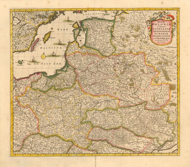
“Regni Poloniae et Ducatus Lithuaniae, Voliniae, Podoliae Ucraniae Prussiae, Livoniae et Curlandiae descriptio”
Map Maker:
Frederick de Wit
Finely engraved map of the region from the Baltic ... (full text available to subscribers)
| Item Detail |
| |
| |
MapMaker: |
Frederick de Wit
|
|
| |
| |
Subject: |
Eastern Europe |
|
| |
Period/Size: |
1706 / 19.0" x 22.0" (48.3 x 55.9 cm)
|
|
| |
Color: |
Colored
|
|
| |
Condition: |
(B) Split on bottom fold with old repair that should be replaced, else very good with beautiful original color with slight oxidation. (condition help) |
|
| |
Source: |
Atlas Minor |
|
| |
References: |
Phillips (A) #5389-106. |
|
| |
|
|
| Sales Information |
| |
| |
Price: |
|
|
| |
| |
Offered by: |
Old World Auctions |
|
| |
Catalog: |
Auction No. 114 - Antique Maps, Charts, Atlases & Globes (567) |
|
| |
Lot/Item #: |
471 |
|
| |
| |
Date: |
03/2006
|
|
| |
| |
|
Antique Maps - Valuation and Pricing, Descriptions, Resources |
|
Home |
Information |
Search |
Register |
Contact Us |
Site Map
Americana Exchange, Inc. © 1999 - 2024 Americana Exchange, Inc.. All rights reserved.
OldMaps.com, the OldMaps.com logo and
AMPR are service marks or registered service marks of Americana Exchange, Inc..
|