Title:
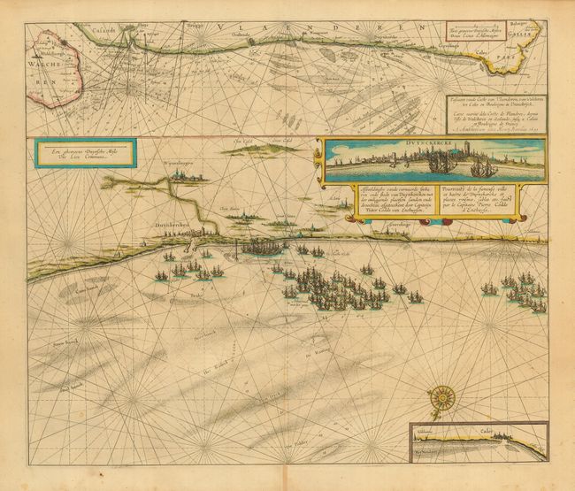
“Afbeeldinghe vande vermaerde zeehaven ende stadt van Duynkercken met der omliggende plaetsen Sanden ende droochten…”
Map Maker:
Henricus Hondius
Impressive sea chart depicts the coast at Dunkerqu... (full text available to subscribers)
| Item Detail |
| |
| |
MapMaker: |
Henricus Hondius
|
|
| |
| |
Subject: |
France & Belgium |
|
| |
Period/Size: |
1631 / 17.0" x 20.0" (43.2 x 50.8 cm)
|
|
| |
Color: |
Colored
|
|
| |
Condition: |
(A) Lightly toned with original color. Couple of insignificant spots, still overall very good. (condition help) |
|
| |
Source: |
|
|
| |
References: |
|
|
| |
|
|
| Sales Information |
| |
| |
Price: |
|
|
| |
| |
Offered by: |
Old World Auctions |
|
| |
Catalog: |
Auction No. 115 - Antique Maps, Charts, Atlases & Globes (568) |
|
| |
Lot/Item #: |
442 |
|
| |
| |
Date: |
06/2006
|
|
| |
| |
|
Antique Maps - Valuation and Pricing, Descriptions, Resources |
|
Home |
Information |
Search |
Register |
Contact Us |
Site Map
Americana Exchange, Inc. © 1999 - 2024 Americana Exchange, Inc.. All rights reserved.
OldMaps.com, the OldMaps.com logo and
AMPR are service marks or registered service marks of Americana Exchange, Inc..
|