Title:
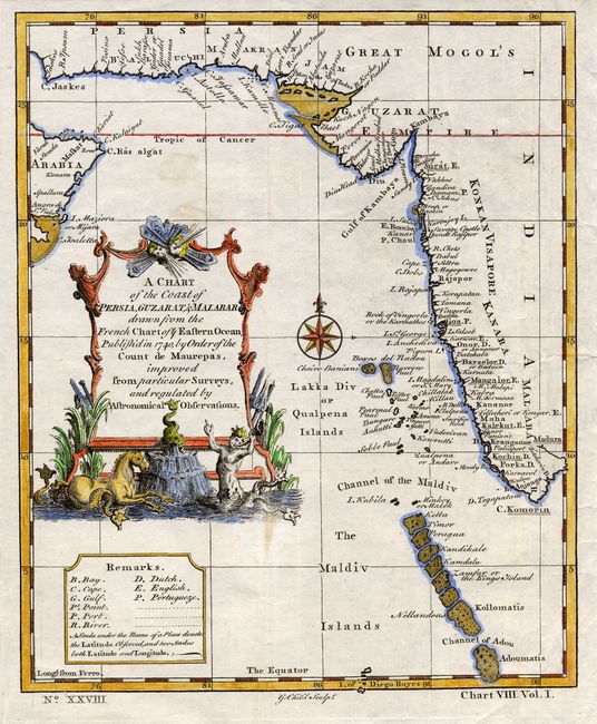
“A Chart of the Coast of Persia, Guzarat, & Malabar drawn from the French chart of ye Eastern Ocean published in 1740 by order of the Count de Maurepas, improved from particular Surveys and regulated by Astronomical Observations.”
Map Maker:
Anonymous
An attractive copper engraved chart centered on th... (full text available to subscribers)
| Item Detail |
| |
| |
MapMaker: |
Anonymous
|
|
| |
| |
Subject: |
Maldives and India |
|
| |
Period/Size: |
1752 / 9.4" x 7.7" (23.9 x 19.6 cm)
|
|
| |
Color: |
Colored
|
|
| |
Condition: |
(A) Strong impression on hand laid paper. Later hand coloring. Two light spots in blank ocean, still very good. (condition help) |
|
| |
Source: |
Universal Traveller |
|
| |
References: |
|
|
| |
|
|
| Sales Information |
| |
| |
Price: |
|
|
| |
| |
Offered by: |
Old World Auctions |
|
| |
Catalog: |
Auction No. 115 - Antique Maps, Charts, Atlases & Globes (568) |
|
| |
Lot/Item #: |
706 |
|
| |
| |
Date: |
06/2006
|
|
| |
| |
|
Antique Maps - Valuation and Pricing, Descriptions, Resources |
|
Home |
Information |
Search |
Register |
Contact Us |
Site Map
Americana Exchange, Inc. © 1999 - 2024 Americana Exchange, Inc.. All rights reserved.
OldMaps.com, the OldMaps.com logo and
AMPR are service marks or registered service marks of Americana Exchange, Inc..
|