Title:
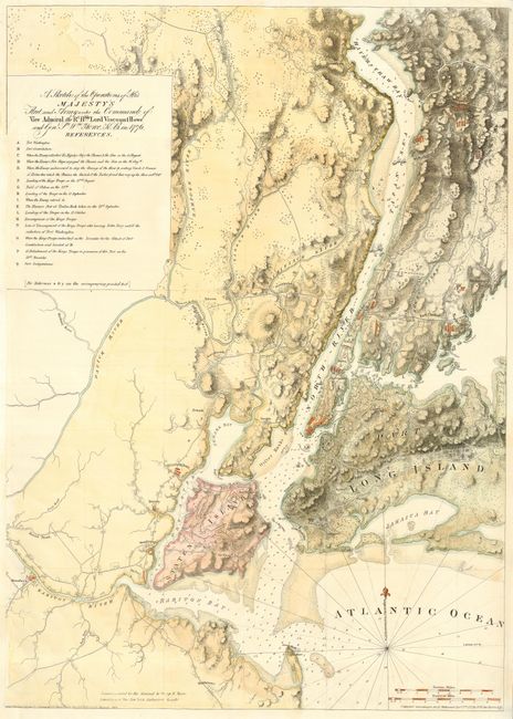
“A Sketch of the Operations of His Majesty's Fleet and Army under the Command of Vice Admiral the Rt. Hble. Lord Viscount Howe and Genl…”
Map Maker:
Joseph Frederick Wallet Des Barres
A nineteenth century reproduction of this importan... (full text available to subscribers)
| Item Detail |
| |
| |
MapMaker: |
Joseph Frederick Wallet Des Barres
|
|
| |
| |
Subject: |
United States - Mid-Atlantic |
|
| |
Period/Size: |
1864 / 31.6" x 22.5" (80.3 x 57.2 cm)
|
|
| |
Color: |
Colored
|
|
| |
Condition: |
(B) Issued folded, now pressed and backed with archival tissue. Some minor repairs of fold separations and a short binding tear. Binding trim replaced to accommodate framing. (condition help) |
|
| |
Source: |
Valentine's Manual |
|
| |
References: |
|
|
| |
|
|
| Sales Information |
| |
| |
Price: |
|
|
| |
| |
Offered by: |
Old World Auctions |
|
| |
Catalog: |
Auction No. 115 - Antique Maps, Charts, Atlases & Globes (568) |
|
| |
Lot/Item #: |
177 |
|
| |
| |
Date: |
06/2006
|
|
| |
| |
|
Antique Maps - Valuation and Pricing, Descriptions, Resources |
|
Home |
Information |
Search |
Register |
Contact Us |
Site Map
Americana Exchange, Inc. © 1999 - 2024 Americana Exchange, Inc.. All rights reserved.
OldMaps.com, the OldMaps.com logo and
AMPR are service marks or registered service marks of Americana Exchange, Inc..
|