Title:
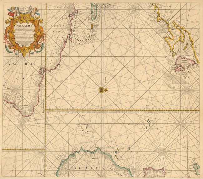
“Paskaert waer in de Graden der Breedde over Weden Zyden vande Middellyn Wassende…”
Map Maker:
van Keulen [Family]
Fine sea chart covering the Atlantic with coastlin... (full text available to subscribers)
| Item Detail |
| |
| |
MapMaker: |
van Keulen [Family]
|
|
| |
| |
Subject: |
Atlantic Ocean |
|
| |
Period/Size: |
1670 / 21.0" x 23.8" (53.4 x 60.5 cm)
|
|
| |
Color: |
Colored
|
|
| |
Condition: |
(B) Light overall toning and a couple of very minor spots and a couple of filled wormholes, else very good. (condition help) |
|
| |
Source: |
|
|
| |
References: |
|
|
| |
|
|
| Sales Information |
| |
| |
Price: |
|
|
| |
| |
Offered by: |
Old World Auctions |
|
| |
Catalog: |
Auction No. 115 - Antique Maps, Charts, Atlases & Globes (568) |
|
| |
Lot/Item #: |
362 |
|
| |
| |
Date: |
06/2006
|
|
| |
| |
|
Antique Maps - Valuation and Pricing, Descriptions, Resources |
|
Home |
Information |
Search |
Register |
Contact Us |
Site Map
Americana Exchange, Inc. © 1999 - 2024 Americana Exchange, Inc.. All rights reserved.
OldMaps.com, the OldMaps.com logo and
AMPR are service marks or registered service marks of Americana Exchange, Inc..
|