Title:
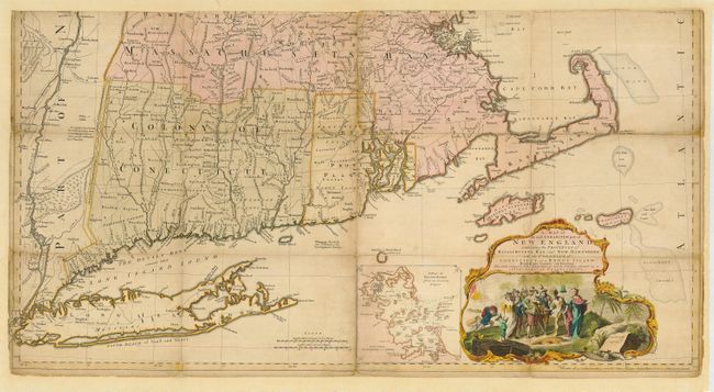
“A Map of the Most Inhabited part of New England containing the Provinces of Massachusetts Bay and New Hampshire with the Colonies of Connecticut and Rhode Island Divided into Counties and Townships…”
Map Maker:
Thomas Jefferys
This is the third edition of Jefferys' celebrated ... (full text available to subscribers)
| Item Detail |
| |
| |
MapMaker: |
Thomas Jefferys
|
|
| |
| |
Subject: |
Colonial New England |
|
| |
Period/Size: |
1774 / 20.5" x 39.0" (52.1 x 99.1 cm)
|
|
| |
Color: |
Colored
|
|
| |
Condition: |
(B) Scattered toning or soiling and other small flaws. Lower margin trimmed to just above neatline. Slight loss at some segment intersections with a little manuscript to Rhode Island. (condition help) |
|
| |
Source: |
|
|
| |
References: |
Tooley (Amer) p.71; McCorkle 755.19; Pritchard & Taliaferro #35; Stevens & Tree #33(e). |
|
| |
|
|
| Sales Information |
| |
| |
Price: |
|
|
| |
| |
Offered by: |
Old World Auctions |
|
| |
Catalog: |
Auction No. 115 - Antique Maps, Charts, Atlases & Globes (568) |
|
| |
Lot/Item #: |
167 |
|
| |
| |
Date: |
06/2006
|
|
| |
| |
|
Antique Maps - Valuation and Pricing, Descriptions, Resources |
|
Home |
Information |
Search |
Register |
Contact Us |
Site Map
Americana Exchange, Inc. © 1999 - 2024 Americana Exchange, Inc.. All rights reserved.
OldMaps.com, the OldMaps.com logo and
AMPR are service marks or registered service marks of Americana Exchange, Inc..
|