Title:
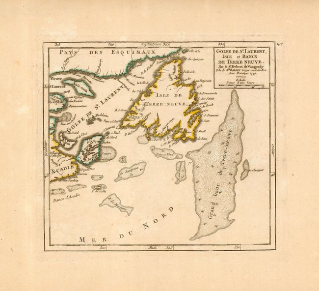
“Golfe de St. Laurent, Isle et Bancs de Terre Neuve”
Map Maker:
Robert de Vaugondy [Family]
Second state of this nice copper engraved map cove... (full text available to subscribers)
| Item Detail |
| |
| |
MapMaker: |
Robert de Vaugondy [Family]
|
|
| |
| |
Subject: |
Canada |
|
| |
Period/Size: |
1749 / 6.3" x 7.0" (16.0 x 17.8 cm)
|
|
| |
Color: |
Colored
|
|
| |
Condition: |
(A) Nice impression printed on a large sheet of hand laid paper with original outline color. Lightly toned. (condition help) |
|
| |
Source: |
Atlas Portatif, Universel et Militaire |
|
| |
References: |
Kershaw #581; Pedley #464. |
|
| |
|
|
| Sales Information |
| |
| |
Price: |
|
|
| |
| |
Offered by: |
Old World Auctions |
|
| |
Catalog: |
Auction No. 116 - Antique Maps, Charts, Atlases & Globes (578) |
|
| |
Lot/Item #: |
104 |
|
| |
| |
Date: |
09/2006
|
|
| |
| |
|
Antique Maps - Valuation and Pricing, Descriptions, Resources |
|
Home |
Information |
Search |
Register |
Contact Us |
Site Map
Americana Exchange, Inc. © 1999 - 2024 Americana Exchange, Inc.. All rights reserved.
OldMaps.com, the OldMaps.com logo and
AMPR are service marks or registered service marks of Americana Exchange, Inc..
|