Title:
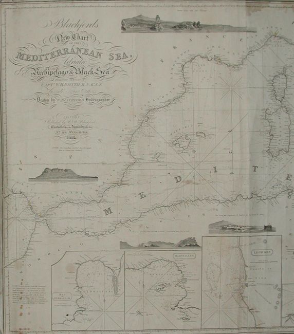
“Blachford's New Chart of the Mediterranean Sea, Adriatic Archipelago & Black Sea from Surveys of Capt. W.H. Smyth”
Map Maker:
Henry William Smyth
A large, blue-backed sea chart is from the surveys... (full text available to subscribers)
| Item Detail |
| |
| |
MapMaker: |
Henry William Smyth
|
|
| |
| |
Subject: |
Mediterranean |
|
| |
Period/Size: |
1828 / 32.0" x 72.0" (81.3 x 182.9 cm)
|
|
| |
Color: |
Black & White
|
|
| |
Condition: |
(B) A generally very sound example with occasional scattered foxing or surface soiling, some marginal staining, a few short tears and occasional marginal roughness. All in all, a nice example for a map this size that was designed for use at sea. (condition help) |
|
| |
Source: |
|
|
| |
References: |
|
|
| |
|
|
| Sales Information |
| |
| |
Price: |
|
|
| |
| |
Offered by: |
Old World Auctions |
|
| |
Catalog: |
Auction No. 116 - Antique Maps, Charts, Atlases & Globes (578) |
|
| |
Lot/Item #: |
680 |
|
| |
| |
Date: |
09/2006
|
|
| |
| |
|
Antique Maps - Valuation and Pricing, Descriptions, Resources |
|
Home |
Information |
Search |
Register |
Contact Us |
Site Map
Americana Exchange, Inc. © 1999 - 2024 Americana Exchange, Inc.. All rights reserved.
OldMaps.com, the OldMaps.com logo and
AMPR are service marks or registered service marks of Americana Exchange, Inc..
|