Title:
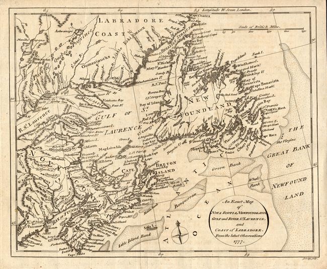
“An Exact Map of Nova Scotia, Newfoundland, Gulf and River St. Laurence, and Coast of Labrador, from the latest Observations”
Map Maker:
John Russell
This uncommon map extends from Penobscot Bay up th... (full text available to subscribers)
| Item Detail |
| |
| |
MapMaker: |
John Russell
|
|
| |
| |
Subject: |
Canada |
|
| |
Period/Size: |
1777 / 8.3" x 10.0" (21.1 x 25.4 cm)
|
|
| |
Color: |
Black & White
|
|
| |
Condition: |
(B) Dark impression on hand laid paper with a large watermark. Near very good example with just a little foxing or toning. A couple of small puncture holes in top margin. (condition help) |
|
| |
Source: |
The History of America |
|
| |
References: |
|
|
| |
|
|
| Sales Information |
| |
| |
Price: |
|
|
| |
| |
Offered by: |
Old World Auctions |
|
| |
Catalog: |
Auction No. 116 - Antique Maps, Charts, Atlases & Globes (578) |
|
| |
Lot/Item #: |
108 |
|
| |
| |
Date: |
09/2006
|
|
| |
| |
|
Antique Maps - Valuation and Pricing, Descriptions, Resources |
|
Home |
Information |
Search |
Register |
Contact Us |
Site Map
Americana Exchange, Inc. © 1999 - 2024 Americana Exchange, Inc.. All rights reserved.
OldMaps.com, the OldMaps.com logo and
AMPR are service marks or registered service marks of Americana Exchange, Inc..
|