Title:
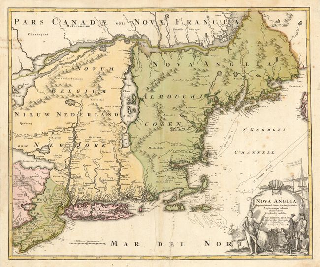
“Nova Anglia Septentrionali Americae implantata Anglorumque coloniis florentissima”
Map Maker:
Johann Baptist Homann
An attractive map showing the English colonies of ... (full text available to subscribers)
| Item Detail |
| |
| |
MapMaker: |
Johann Baptist Homann
|
|
| |
| |
Subject: |
Colonial New England and Mid-Atlantic |
|
| |
Period/Size: |
1724 / 19.2" x 23.0" (48.8 x 58.5 cm)
|
|
| |
Color: |
Colored
|
|
| |
Condition: |
(B) Original color. Toned along fold with a few scattered spots and stains. Backed with heavy tissue to support some paper weakness and repair a tear (or printer's crease?) just right of bottom centerfold. Paper is now sound and it is an attractive map (condition help) |
|
| |
Source: |
|
|
| |
References: |
McCorkle #724.1; Portinaro & Knirsch #116; Sellers and Van Ee #806. |
|
| |
|
|
| Sales Information |
| |
| |
Price: |
|
|
| |
| |
Offered by: |
Old World Auctions |
|
| |
Catalog: |
Auction No. 116 - Antique Maps, Charts, Atlases & Globes (578) |
|
| |
Lot/Item #: |
148 |
|
| |
| |
Date: |
09/2006
|
|
| |
| |
|
Antique Maps - Valuation and Pricing, Descriptions, Resources |
|
Home |
Information |
Search |
Register |
Contact Us |
Site Map
Americana Exchange, Inc. © 1999 - 2024 Americana Exchange, Inc.. All rights reserved.
OldMaps.com, the OldMaps.com logo and
AMPR are service marks or registered service marks of Americana Exchange, Inc..
|