Title:
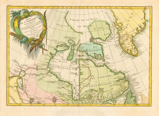
“Partie de l'Amerique Septentrionale qui comprehend le Canada, la Louisiane, le Labrador, le Groenland, les Etats-Unis et la Florida”
Map Maker:
Bonne/Lattre
Third state of this lovely map that covers eastern... (full text available to subscribers)
| Item Detail |
| |
| |
MapMaker: |
Bonne/Lattre
|
|
| |
| |
Subject: |
Canada |
|
| |
Period/Size: |
1783 / 11.7" x 17.0" (29.8 x 43.2 cm)
|
|
| |
Color: |
Colored
|
|
| |
Condition: |
(A+) (condition help) |
|
| |
Source: |
Atlas Moderne ou collection de Cartes sur toutes les Parties du Globe Terrestre |
|
| |
References: |
Kershaw #475; McCorkle #771.2. |
|
| |
|
|
| Sales Information |
| |
| |
Price: |
|
|
| |
| |
Offered by: |
Old World Auctions |
|
| |
Catalog: |
Auction No. 116 - Antique Maps, Charts, Atlases & Globes (578) |
|
| |
Lot/Item #: |
110 |
|
| |
| |
Date: |
09/2006
|
|
| |
| |
|
Antique Maps - Valuation and Pricing, Descriptions, Resources |
|
Home |
Information |
Search |
Register |
Contact Us |
Site Map
Americana Exchange, Inc. © 1999 - 2024 Americana Exchange, Inc.. All rights reserved.
OldMaps.com, the OldMaps.com logo and
AMPR are service marks or registered service marks of Americana Exchange, Inc..
|