Title:
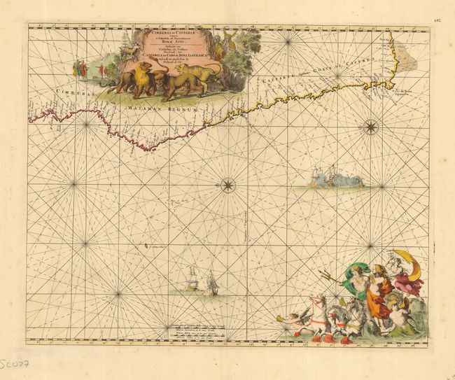
“Cimbebas et Caffariae Littora a Catenbela ad Promontorium Bonae Spei…”
Map Maker:
Frederick de Wit
A superb sea chart with the African coastline draw... (full text available to subscribers)
| Item Detail |
| |
| |
MapMaker: |
Frederick de Wit
|
|
| |
| |
Subject: |
Africa - Southern |
|
| |
Period/Size: |
1680 / 16.8" x 21.0" (42.7 x 53.4 cm)
|
|
| |
Color: |
Colored
|
|
| |
Condition: |
(A+) Excellent with old color and just a couple of spots of foxing in blank margins. (condition help) |
|
| |
Source: |
Orbis Maritimus ofte Zee Atlas |
|
| |
References: |
|
|
| |
|
|
| Sales Information |
| |
| |
Price: |
|
|
| |
| |
Offered by: |
Old World Auctions |
|
| |
Catalog: |
Auction No. 117 - Antique Maps, Charts, Atlases & Globes (579) |
|
| |
Lot/Item #: |
831 |
|
| |
| |
Date: |
12/2006
|
|
| |
| |
|
Antique Maps - Valuation and Pricing, Descriptions, Resources |
|
Home |
Information |
Search |
Register |
Contact Us |
Site Map
Americana Exchange, Inc. © 1999 - 2024 Americana Exchange, Inc.. All rights reserved.
OldMaps.com, the OldMaps.com logo and
AMPR are service marks or registered service marks of Americana Exchange, Inc..
|