| Item Detail |
| |
| |
MapMaker: |
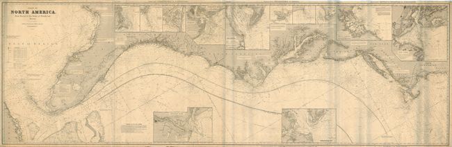
John William Norie
|
|
| |
| |
Subject: |
Eastern United States |
|
| |
Period/Size: |
1896 / 33.8" x 105.5" (85.8 x 268.0 cm)
|
|
| |
Color: |
Black & White
|
|
| |
Condition: |
(B) Clean, sharp impression, rolled as issued with a couple light stains. There are only two short tears on the right and left edge, just into neatline, the longest of which has been stopped with archival tape on the verso. Still very good for a map of (condition help) |
|
| |
Source: |
|
|
| |
References: |
|
|
| |
|
|
| Sales Information |
| |
| |
Price: |
|
|
| |
| |
Offered by: |
Old World Auctions |
|
| |
Catalog: |
Auction No. 117 - Antique Maps, Charts, Atlases & Globes (579) |
|
| |
Lot/Item #: |
152 |
|
| |
| |
Date: |
12/2006
|
|
| |
| |
|