Title:
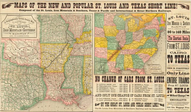
“Maps of the New and Popular St. Louis and Texas Short Line! Composed of the St. Louis, Iron Mountain & Southern, Texas & Pacific and International & Great Northern Railways.”
Map Maker:
Railroad Companies
Folding pocket railroad timetable that promises "8... (full text available to subscribers)
| Item Detail |
| |
| |
MapMaker: |
Railroad Companies
|
|
| |
| |
Subject: |
United States - Texas and Midwest |
|
| |
Period/Size: |
1878 / 18.0" x 31.0" (45.8 x 78.8 cm)
|
|
| |
Color: |
Colored
|
|
| |
Condition: |
(B) Very nice example of this folding map with a stain in a primarily blank area of the sheet and a couple of the typical fold separations at intersections. (condition help) |
|
| |
Source: |
|
|
| |
References: |
|
|
| |
|
|
| Sales Information |
| |
| |
Price: |
|
|
| |
| |
Offered by: |
Old World Auctions |
|
| |
Catalog: |
Auction No. 117 - Antique Maps, Charts, Atlases & Globes (579) |
|
| |
Lot/Item #: |
190 |
|
| |
| |
Date: |
12/2006
|
|
| |
| |
|
Antique Maps - Valuation and Pricing, Descriptions, Resources |
|
Home |
Information |
Search |
Register |
Contact Us |
Site Map
Americana Exchange, Inc. © 1999 - 2024 Americana Exchange, Inc.. All rights reserved.
OldMaps.com, the OldMaps.com logo and
AMPR are service marks or registered service marks of Americana Exchange, Inc..
|