Title:
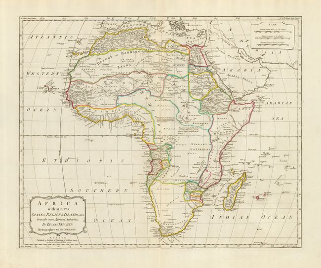
“Africa with All Its States, Regions, Islands, &ca. from the most Approved Authorities”
Map Maker:
Thomas Kitchin
This lovely map of the continent presents the poli... (full text available to subscribers)
| Item Detail |
| |
| |
MapMaker: |
Thomas Kitchin
|
|
| |
| |
Subject: |
Africa |
|
| |
Period/Size: |
1794 / 17.0" x 21.0" (43.2 x 53.4 cm)
|
|
| |
Color: |
Colored
|
|
| |
Condition: |
(A) A very fine example with strong color and impression printed on thick hand laid paper with wide margins. Huge watermark features a crown and fleur-de-lys. Small amount of foxing in margin at lower left, else fine. (condition help) |
|
| |
Source: |
|
|
| |
References: |
cf Rumsey 2523 (larger edition). |
|
| |
|
|
| Sales Information |
| |
| |
Price: |
|
|
| |
| |
Offered by: |
Old World Auctions |
|
| |
Catalog: |
Auction No. 117 - Antique Maps, Charts, Atlases & Globes (579) |
|
| |
Lot/Item #: |
795 |
|
| |
| |
Date: |
12/2006
|
|
| |
| |
|
Antique Maps - Valuation and Pricing, Descriptions, Resources |
|
Home |
Information |
Search |
Register |
Contact Us |
Site Map
Americana Exchange, Inc. © 1999 - 2024 Americana Exchange, Inc.. All rights reserved.
OldMaps.com, the OldMaps.com logo and
AMPR are service marks or registered service marks of Americana Exchange, Inc..
|