Title:
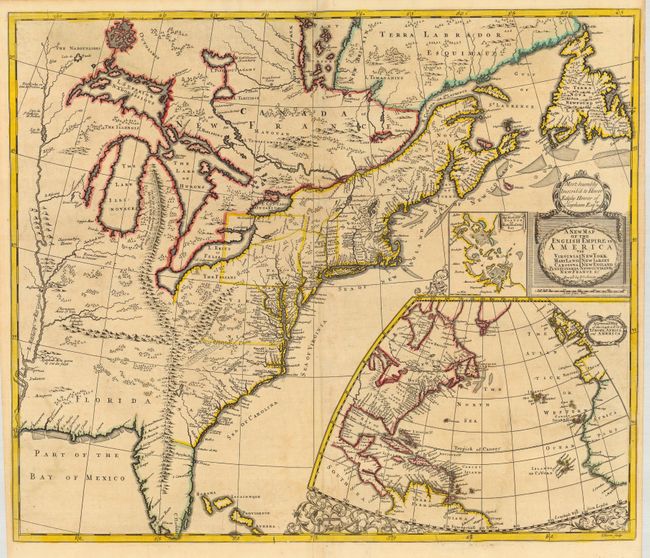
“A New Map of the English Empire in America viz Virginia, Maryland, Carolina, New York, New Iarsey, New England…”
Map Maker:
Morden/Senex
This is a great map of the eastern part of North A... (full text available to subscribers)
| Item Detail |
| |
| |
MapMaker: |
Morden/Senex
|
|
| |
| |
Subject: |
Colonial United States and Canada |
|
| |
Period/Size: |
1719 / 19.8" x 23.3" (50.3 x 59.2 cm)
|
|
| |
Color: |
Colored
|
|
| |
Condition: |
(A) Generally very good with nice original outline color. Couple of minor repairs in bottom margin and border and a bit of faint offsetting. (condition help) |
|
| |
Source: |
A New General Atlas |
|
| |
References: |
Cumming (SE) #172; Kershaw #326; McCorkle #719.7; Stevens & Tree #20b. |
|
| |
|
|
| Sales Information |
| |
| |
Price: |
|
|
| |
| |
Offered by: |
Old World Auctions |
|
| |
Catalog: |
Auction No. 117 - Antique Maps, Charts, Atlases & Globes (579) |
|
| |
Lot/Item #: |
114 |
|
| |
| |
Date: |
12/2006
|
|
| |
| |
|
Antique Maps - Valuation and Pricing, Descriptions, Resources |
|
Home |
Information |
Search |
Register |
Contact Us |
Site Map
Americana Exchange, Inc. © 1999 - 2024 Americana Exchange, Inc.. All rights reserved.
OldMaps.com, the OldMaps.com logo and
AMPR are service marks or registered service marks of Americana Exchange, Inc..
|