Rister or Sign In to see pricing information


Title:

Carta particolare della Meta Inconita con la Gronlandia Occidentale e dell' Estotiland Scop. Dall' Inglesi

Map Maker:

Robert Dudley

Carta particolare della Meta Inconita con la Gronlandia Occidentale e dell' Estotiland Scop. Dall' Inglesi

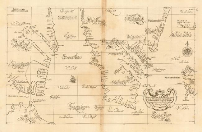
This scarce map is the first sea chart of the Nort... (full text available to subscribers)
Item Detail
 
  MapMaker:  

Robert Dudley


  Subject:  North Atlantic - Greenland  
  Period/Size:  1661 / 17.7" x 29.0"  (45.0 x 73.7 cm)  
  Color:  Black & White  
  Condition:  (B) Exquisitely sharp impression. There is some toning along the joint and a couple of spots of foxing. (condition help)  
  Source:  Arcano del Mare  
  References:  Burden #274.  
 
 
Sales Information
 
  Price: 

Please register your email to view records, or sign in with email address to see records


  Offered by:  Old World Auctions  
  Catalog:  Auction No. 118 - Antique Maps, Charts, Atlases & Globes (584)  
  Lot/Item #:  522  
 
  Date:  03/2007  


Antique Maps - Valuation and Pricing, Descriptions, Resources


Home | Information | Search | Register | Contact Us | Site Map

Americana Exchange, Inc. © 1999 - 2024 Americana Exchange, Inc.. All rights reserved. OldMaps.com, the OldMaps.com logo and
AMPR are service marks or registered service marks of Americana Exchange, Inc..